

Complete Visual Documentation
Accurate. Professional. Permanent.
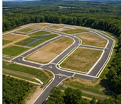
Our as-built completion services proved contractors, developers, and property owners with high-resolution aerial documentation of completed construction projects.
-
Aerial Photography
-
Orthomosaic Maps
-
3D Models
-
Site Overviews
-
Completion Imagery
-
Stakeholder-Ready Reports
These records help preserve accurate visual documentation for project closeout, marketing, compliance, and long-term reference.

OUR DELIVERABLES
Comprehensive As-Built Documentation
OUR DELIVERABLES
Comprehensive As-Built Documentation
Aerial Completion Photography
High-resolution final imagery of the completed project.
Orthomosaic Mapping
Accurate aerial site maps with measurements for final documentation.
3D As-Built Models
Interactive 3D models of structure and sites for visualization and records.
Site Overview Report
Organized deliverables for project records and stakeholders.
Marketing Imagery
Professional imagery for portfolio, leasing, and promotion.
OUR DELIVERABLES
Completed Projects


WHY IT MATTERS
Why Contractors Use As-Built Documentation
Final Project Records
Maintain visual documentation after completion.
Stakeholder Deliveriables
Provide organized visual records to owners and investors.
Marketing & Leasing
Use professional imagery for future marketing and leasing.
Long-Term Reference
Create accurate archived visuals of completed conditions.
Compliance & Documentation
Support closeout packages and project records.
Our Process
1
We learn about your project, goals, challenges and needs.
2
We develop the right mission plan and deliverables for your project.
3
We collect high-quality aerial data using advanced equipment.
4
We process and analyze data to deliver accurate, actionable insights.
5
You receive easy-to-use deliverables on time, every time.
Plan with a clearer view.
Capture existing site conditions, access routes, surrounding property features, grading conditions, and project context before work begins.
Track every milestone from above.
Document site progress with scheduled aerial photography and video updates that keep owners, contractors, and stakeholders informed.
Deliver proof of progress and a polished finish.
Professional final imagery that documents completed work and provides strong assets for project records, portfolios, and marketing.