

PROGRESS MONITORING AND REPORTING
TRACK EVERY MILESTONE
FROM ABOVE
Construction projects move fast — and clear documentation matters.
Lance Geospatial Solutions provides recurring aerial progress monitoring and reporting services that help contractors, developers, and project managers maintain visibility across every stage of a project.
Using drone imagery, mapping, and visual reporting tools, we help teams communicate progress clearly, document milestones, and maintain accurate project records from groundbreaking to completion.
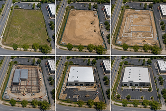
WEEKLY/MONTHLY
PROGRESS FLIGHTS
Consistent aerial updates captured from the same viewpoints over time to clearly document project progress.
AERIAL PROGRESS PHOTOGRAPHY
High-resolution aerial imagery showing current site conditions and completed work.
CINEMATIC SITE
VIDEOS
Professional aerial video updates that showcase project growth and milestones.
MAPPING &
ORTHOMOSAICS
Accurate aerial maps that provide a full-site overview for planning and tracking.
Safety
Oversight
Marketing and Shareholder Reporting
Property and Boundary Mapping
Pre-Construction Site Assessments
As-Built Visual Documentation
Why Construction Teams Use Progress Monitoring...
Improve Communication
Provide clear visual updates to owners, investors, and stakeholders.
Document Milestones
Create a detailed visual history of the project from start to finish.
Increase Accountability
Track work progress and maintain consistent project documentation.
Reduce Site Visits
Give remote stakeholders a clear view of site activity without needing to travel.
Improve Marketing
Showcase project growth with professional aerial imagery and video.
Our Process
1
We learn about your project, goals, challenges and needs.
2
We develop the right mission plan and deliverables for your project.
3
We collect high-quality aerial data using advanced equipment.
4
We process and analyze data to deliver accurate, actionable insights.
5
You receive easy-to-use deliverables on time, every time.
Plan with a clearer view.
Capture existing site conditions, access routes, surrounding property features, grading conditions, and project context before work begins.
Track every milestone from above.
Document site progress with scheduled aerial photography and video updates that keep owners, contractors, and stakeholders informed.
Deliver proof of progress and a polished finish.
Professional final imagery that documents completed work and provides strong assets for project records, portfolios, and marketing.